KASCADE stands for KAtabatic winds and Stability over CADarache for Dispersion of Effluents. The project was designed to increase the understanding of the local and regional meteorology around Cadarache, the largest research site of Commissariat à l’Energie Atomique et aux Energies Alternatives (CEA), and to develop and improve numerical models of pollutant dispersion, asthe Centre comprises several facilities whose operation requires impact assessment considering the emission of pollutants. Cadarache is located in the Provence prealps, in south-eastern France. This region is susceptible to stable stratification periods which, in combination with the complex orography, affects the conditions for dispersion of pollutants.
KASCADE 2013
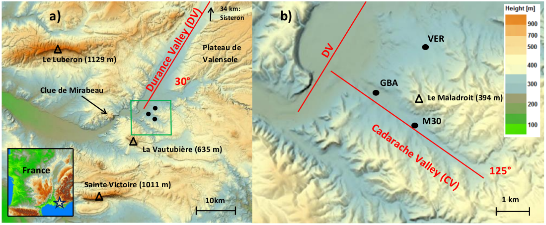
KASCADE 2013 was mainly focused on studying the vertical structure of down-valley winds in two cross-oriented valleys of different size, the Durance and Cadarache valley (see figure below). The experiment has been conducted during three months in the winter of 2013 and was designed to characterize the local stable boundary layer and the associated thermally driven winds. The campaign included continuous observations from December 2012 to March 2013 as well as 23 intensive observational periods (IOPs) in January and February.
The campaign consisted in a combination of profiling systems (SODAR, tethered balloon, radiosoundings), turbulence and radiation observations (flux divergence tower), and standard meteorological observations at different sites and heights. In this way the field campaign is designed to investigate the role of several key parameters for stable boundary layer formation and the consequent (valley) winds. All instruments have been calibrated afterwards. Details regarding experimental set-up, observation strategy, data processing and IOPs meteorology can be found in Duine’s PhD thesis, in Duine et al. paper (QJRMS 2017) and in a technical document (Duine, 2014), available in the “Documents” tab.

KASCADE 2017
KASCADE 2017 was mainly focused on study of the spatial heterogeneity of meteorological parameters near the surface in the Cadarache valley with a special interest on spatial and temporal development of valley winds in relation to stable stratification. To do so, most of the meteorological stations were located along two axes: on the bottom of the valley along its main axis, and along a cross-valley axis (see figure below). Such a setting-up allows the observation of slope winds on both flanks of the valley, and of the valley wind on its bottom. It also yields a measure of he stratification along the slopes of the valley which can be different from that in its central part.

Continuous measurements were performed from December 15th, 2016 to May 31st, 2017. Most of these observations were performed near the surface, except for the sodar which measures wind profiles. Additional profiles were obtained with frequent radiosoundings and temperature sensors under a tethered balloon during 14 24-hr IOPs between January and March.